Geophysical measurements (surveys, gravimetry, seismic, VES)
WMS service contains information on geophysical measurements, layers of gravimetry and seismic vertical electric sounding (VES) on the territory of the Czech Republic.
service
https://registry.geology.cz/id/GFY-MERENI_PRZ-SDE-WMS
WMS
1.3.0
European Geoscience Registry - Projects:
Spatial scope:
ISO 19119:
CGS Geoscientific themes:
GEMET - INSPIRE themes, version 1.0:

Free:
CzechGeo
11.803630,
47.478946,
20.119406,
51.418931
publication: 2021-01-31, creation: 2018-12-01
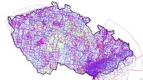
Measurements were made mainly by Geofyzika Brno since the early 1950s. Areas covered by regional surveys are depicted on 1:200 000 scale maps and local small-scale measurements at scale of 1:50 000.
Ing. Martin Paleček
Leitnerova 204/22,
Brno,
602 00,
Česká republika
tel: +420543429261
email:
martin.palecek@geology.cz
Role: point of contact
Klárov 131/3,
Praha 1,
118 00,
Česká republika
tel: +420257089411
email:
metadata@geology.cz
Role: custodian
Data Quality
Constraints
Metadata about metadata
60913439-23dc-488e-9858-46210a010852
Mgr. Pavla Kramolišová
Kostelní 364/26,
Praha 7,
170 00,
Česká republika
tel: +420 234 742 161
email:
pavla.kramolisova@geology.cz
Role: point of contact
2025-04-24